SIRSI TOORISAM
Friday, 15 March 2013
Friday, 20 May 2011
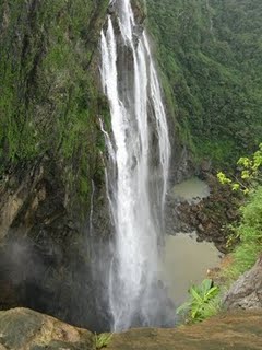
Jog Falls
Jog Falls is situated on the borders of Shimoga and North Kanara, 100 from Shimoga city.
The Western Ghats gives rise to the Sharavati river that plunges from a height of 829 feet in four magnificent cascades namely Raja, Rani, Roarer and Rocket. Jog falls, being the tallest waterfalls in India is situated in the dense evergreen forests, 16kms from Talguppa nearest railway station, Shimoga district, Karnataka You can also reach this falls en route National Highway 48 or 4. The effect is greatly heightened by the wild and beautiful region around which is covered with a wealth of luxuriant vegetation. The steps cut into rocks will lead you to the very depths of the fall and shower you with vaporous spray that bounces off these rocks.
The Western Ghats gives rise to the Sharavati river that plunges from a height of 829 feet in four magnificent cascades namely Raja, Rani, Roarer and Rocket. Jog falls, being the tallest waterfalls in India is situated in the dense evergreen forests, 16kms from Talguppa nearest railway station, Shimoga district, Karnataka You can also reach this falls en route National Highway 48 or 4. The effect is greatly heightened by the wild and beautiful region around which is covered with a wealth of luxuriant vegetation. The steps cut into rocks will lead you to the very depths of the fall and shower you with vaporous spray that bounces off these rocks.
The Western Ghats constitute the beautiful array of mountains along the western coast of India .
The Western Ghats constitute the beautiful array of mountains along the western coast of India that separates the Deccan Plateau from a narrow coastal strip along the Arabian Sea. It is a `virtual` mountain range in the sense that it is a fractured extension of the Deccan Plateau probably formed during the break up of the super continent Gondwana. The range starts from the southern part of the Tapti River near the border area of Gujarat and Maharashtra . It covers a length of around 1600 km running through the states of Maharashtra, Goa, Karnataka, Tamil Nadu and Kerala finally culminating at Kanyakumari, in the southern-most tip of the Indian peninsula. Covering an area of 60,000 sq. kilometres they form the catchment area for a large number of rivers draining almost 40% of the Indian sub-continent. Mountains, Gaps and Passes
The Western Ghats have an average elevation of 1200 metres. However, in certain places they rise abruptly to a height of over 2440 metres. The Western Ghats of Maharashtra, extending from the Satpura Range to the north, travels south past Goa to Karnataka. The chief hill range of the segment is the Sayadhri range. Here we have two high peaks, Kalsubai, having a height of 1646 metres and Salher having a height of 1567 metres.The Western Ghats are home to a number of gaps and passes, notable among them being the Thal Ghat and the Bhor Ghat. They link the interior of the Deccan with Mumbai. The southern part of the Western Ghats harbour the Nilgiri hills (the word Nilgiri meaning "Blue Mountains" ) which serve as the meeting point o the Western and Eastern Ghats. The Nilgiris show a steep rise from the plains and enclose between them the Karnatak Plateau. The Nilgiri Hills are fhome to two of the highest peaks of the Western Ghats : Dodabetta, having a height of 2637 metres and Makurti, having a height of 2554 metres. To the south of the Nilgiri Hills is located the Palghat gap, extending from the east to the west of the Ghats. With a width of 24 km , the Palghat gap is an easy passageway across the Western Ghats.To the south of the Nilgiris are the Anaimalai, Cardamom and Palni hills. The Anaimudi is the highest peak in Peninsular India. It is situated in the Anaimalai hills and has a height of 2695 metres.
The narrow coastal plain between the Western Ghats and the Arabian Sea is known as the Konkan Coast in the north and the Malabar Coast in the south. The largest city amidst these mountains is Pune.
YANA
Sirsi: Yana- nature's wonder- 40kms from Sirsi and 30kms from Kumta in Uttara Kannada district, located near the river Chandrika, is encircled By thickly wooded forest. It is known for two gigantic rock formation of a height of 90 meters and 120 meters called Mohini Shikhara (hill) and Bhairaveshwar Shikhara. The needle sharp peaks of these two monoliths Jab the sky.
It is a trekker’s paradise. One can eliminate his fatigue by bathing in the Beautiful cascades of Chandrika rivulet coming down the hills. Bhairaveshwara temple, Bhairaveshwara shikhara and a cave inside the rock formations are Added attractions.
It is a trekker’s paradise. One can eliminate his fatigue by bathing in the Beautiful cascades of Chandrika rivulet coming down the hills. Bhairaveshwara temple, Bhairaveshwara shikhara and a cave inside the rock formations are Added attractions.
UNCHALLI FALLS
Unchalli Falls of Karnataka is one of the most beautiful picturesque waterfalls in India. The Unchalli Falls is also known as Lushington Falls because it was discovered by JD Lushington, a district collector of the British Government. Unchalli Falls is a perfect spot for those who want to explore the nature's beauty. The waterfall is surrounded by natural vegetation from all sides to preserve its beauty.
Subscribe to:
Comments (Atom)


